Trail Bicycle tourism Les Rousses - LES ROUSSES - SAINT CLAUDE  - Photo

LES ROUSSES - SAINT CLAUDE

© OpenStreetMap contributors
Length
Length
69 km
Max alt
Max alt
1232 m
Uphill gradient
Uphill gradient
1446 m
Km-Effort
Km-Effort  
88 km
Min alt
Min alt
416 m
Downhill gradient
Downhill gradient
1443 m
Boucle
Boucle
No
Creation date :
2023-06-28 06:53:47.923
Updated on :
2023-06-28 15:42:30.606

(0 Reviews)

Bicycle tourism
Bicycle tourism
6h15
Difficulty : Difficult

Scan this QR Code to open this trail in the SityTrail application

FREE GPS app for hiking

Logo SityTrail SityTrail

IGN / Geographical institutes

Download SityTrail from the App Store Download SityTrail from Google Play

Logo SityTrail SityTrail World

The world is yours!

Download SityTrail from the App Store Download SityTrail from Google Play Download SityTrail on Huawei AppGallery

About

Trail Bicycle tourism of 69 km to be discovered at Bourgogne-Franche-Comté, Jura, Les Rousses. This trail is proposed by jean-marie.parachini.

Description

randonnée vers Morez et Morbier par la nationale 5 puis les gorges de la Bienne par D26 et D437 pour descendre sur Saint Claude.
Remontée par gorges du Flumer vers Septmoncel et Lamoura. retour aux Rousses par Premanon.

Elevation profile

Photos

Positioning

Country:
France
Region :
Bourgogne-Franche-Comté
Department/Province :
Jura
Municipality :
Les Rousses
Location:
Unknown
Start:(UTM)
274258 ; 5152874 (32T) N.

Trails nearby

Trail Cycle  - Lac de Lamoura et Valserine - Prémanon - Photo
Cycle
tracegps

Cycle

Medium
(1)
, Bourgogne-Franche-Comté, Jura, France
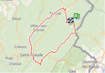
39 km | 49 km-effort
2h 0min
Yes
Trail Walking  - Le Belvédère des Maquisards - Prémanon - Photo
Walking
tracegps

Walking

Medium
(1)
, Bourgogne-Franche-Comté, Jura, France
5.4 km | 7.8 km-effort
2h 0min
Yes
Trail Walking  - Autour de Prémanon - Photo
Walking
tracegps

Walking

Very difficult
(1)
, Bourgogne-Franche-Comté, Jura, France
18 km | 27 km-effort
6h 0min
Yes
Trail Walking Les Rousses - Le Noirmont - Les Rousses - Photo
Walking
tracegps

Walking

Very difficult
(2)
Les Rousses, Bourgogne-Franche-Comté, Jura, France
15.1 km | 23 km-effort
6h 0min
Yes
Trail On foot  - Les Arcets - Photo
On foot
PRO

On foot

Easy
, Bourgogne-Franche-Comté, Jura, France
9 km | 13.6 km-effort
3h 5min
Yes
Trail Walking  - Prémanon, Mont Fier  - Photo
Walking
MoiClaude

Walking

Very easy
(1)
, Bourgogne-Franche-Comté, Jura, France
10.9 km | 15.8 km-effort
2h 34min
No
Trail Snowshoes Les Rousses - Lac des Rousses  - Photo
Snowshoes
nfranche

Snowshoes

Medium
(1)
Les Rousses, Bourgogne-Franche-Comté, Jura, France
13.8 km | 18.4 km-effort
4h 15min
Yes
Trail Walking Les Rousses - Noirmont et Creux du Croue - Photo
Walking
DanElise

Walking

Very easy
(1)
Les Rousses, Bourgogne-Franche-Comté, Jura, France
12.2 km | 19.8 km-effort
4h 18min
Yes
Trail Bicycle tourism Les Rousses - LES ROUSSES - PARCOURS EST VERS LA SUISSE  - Photo
Bicycle tourism
jean-marie.parachini

Bicycle tourism

Difficult
Les Rousses, Bourgogne-Franche-Comté, Jura, France
67 km | 85 km-effort
7h 18min
Yes


Close
My subscriptions